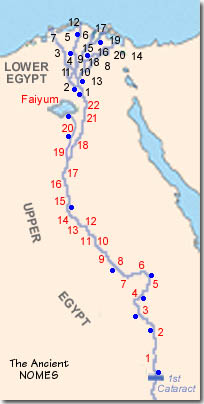
The Nile Valley forms a series of natural basins along
its length, like beads on a string. In the earliest Predynastic
Period (ca. 4500 BC), nomadic tribes drifted into the Nile Valley
from the desert and settled down. They formed clusters of villages
and fields in each basin. The basins eventually became naturally autonomous
territorial divisions known since ancient times as nomes.
Each nome had its own sacred plant or animal which became
the totem, fetish or emblem of that basin. The emblem was depicted
on the pottery of the area. These totemic entities eventually contributed
their characteristics to the local netjer
(divinity of the Egyptian pantheon).
There were 22 nomes in Upper Egypt and 20 in Lower Egypt.
The first pharaohs used naval mobility and the strategic
position of the Nile (which flowed through the middle of each nome)
to seize complete military control and unify the nation. They established
centralized command over irrigation, flood control, and food distribution.
They appointed royal governors for each nome, answerable to the pharaoh.This
nome-based administrative system remained essentially unchanged for
over 3,500 years.
But during weak dynasties, or in times of anarchy and
civil war, the nomes again asserted their ancient independence. The
nomarchs - the local nome governors - gained greater of lesser
degrees of power. Sometimes a particular nomarch family could even
fight its way to national power, defeat rival nomarchs, unify the
Two Lands, and start a new dynasty!